
This trip takes you deep into the high desert country south and west of Cuba to a really out of the way archeological site, Guadalupe Ruin. Most of the time this is a trip that can be driven in any high centered sedan (no Honda Civics or the like, though), but there a couple of spots that make us advise a 4-wheel drive vehicle. About 100 miles roundtrip from Cuba, this trip really gets you into the wilds. All measurements by GPS.
This is at least a half-day trip over mostly dirt roads and can be a very nice full day trip. Normally, a reasonably high-centered sedan can make the trip, but there is one DEEP wash just a mile before the ruins that, for us, on one trip, was benign, then on the second, about three days after rain, was very scary. We’ll talk about it when we get there in the directions.
Go south from Cuba on Highway 550 to MP 41.6. A paved road heading to the SW is the road to San Luis. Start mileage reading here. It is 5.5 miles on paved road to the little community of San Luis. Continue south to mile 8.5 where the paved road makes a right turn, but continue straight onto a wide, well traveled dirt road. At 12.3 miles, there is a road to the left, but continue straight out across a wide valley. At 13.8 miles continue straight. 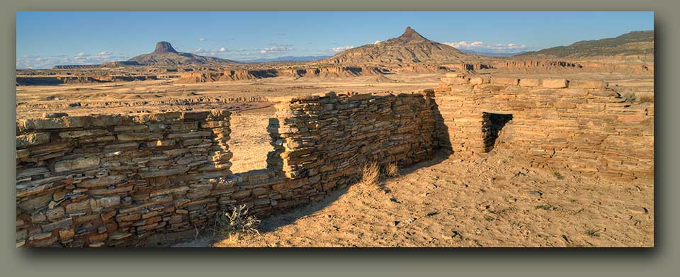
At about 17.2 miles you make a sweeping left turn and top a rise, stay left on the main road. At 18.8 miles you are at the edge of the mesa and looking down at the Arroyo Chico Wash. Here you drop down into the lower valley and cross a one-lane bridge over Arroyo Chico at 20.2 miles. Stay on the main traveled road until 21.5 miles where you turn left onto CR 278. Stay on the main traveled road.
At 26.5 miles the wash to your left is the Rio Puerco River and right about here you pass into a stretch of private property. You drive through some very interesting old adobe ruins, especially the building immediately on your left, which at one time was a house of “ill-repute.” However, please note that you are on a right-of-way through private property and the only “right” you have is to drive through.
Soon the road bears off to the right and then drops down into a deep wash and, while it looks fearsome, is actually easily traversed UNLESS, unless it has water in it. If it’s running water and looks deep, it probably is and you should not try to cross. If it’s standing water, you might try the ol’ “wade in and find out how deep it is” method.
At mile 29.7, there is a truly fearsome, deep, deep wash you will want to treat with a great deal of respect. They could make a scary movie here. The road makes a STEEP dive down an extremely narrow cut about 30 feet to a narrow bottom, then, like a roller coaster, climbs STEEPLY back up the other side, with a sharp right turn about halfway up just to add interest to the whole maneuver. One time we came through and just about any sedan could have made it. The next time, three days after some pretty good rains, the bottom was a literal mud-swamp of deep, clingy caliche. My theory is, the walls of the wash and beside the road are so narrow, sunlight only gets to the bottom for about ½ hour every day and so mud hangs around for a long time, probably long enough to evolve whole new species.
We raced through in 4-wheel drive, slipping, skidding, praying and just oozing out the other side at 10 mph. So, what I’m saying here is, check this out pretty good before making the run!
Finally, at mile 30.7, just immediately after you top a rise, on your left, there is a small, not very well defined parking lot. Well, actually, a clear space with a lot of tire tracks. Park here, lock up, pass through the angled “people passer” in the fence and you are on the trail leading to Guadalupe Ruins. It is about a tenth of a mile to the ruin, but it is a very steep tenth of a mile and the elevation rise is about 100’.
You are at the base of a very steep-walled mesa. The trail is fairly well defined and rises steeply up past a couple of information signs placed here by the Feds. Just past the second sign the trail turns to the left and goes along the base of the cliff to a point where it zigs and zags up to a saddle and then steeply again to the NE to the top of the mesa where the ruins are.
Whoever lived here could see a long way in any direction. The Rio Puerco River, which you can see running down to the NE of you, was the life-force for the Indians here in their agrarian life style. Immediately to the NE is Cerro Cochino and off in the distance is Cabezon. Spotted here and there are old ranch sites, some abandoned, some still lived in, a ranching history that goes back 200 years.
Guadalupe Ruin is a “Chacoan Outlier Site” on an isolated mesa about 65 air miles southeast of Chaco Canyon and a 100-mile roundtrip by road from Cuba. From the top of Guadalupe Mesa is a grand, wonderful panorama of many mountains and volcanic plugs, including the spectacular Cabezon to the northeast. Plan to get here about 2 hours before sunset for the best photography.
The ruin is at the center and highest point of the mesa on which it sits. The ruin is long and narrow, constricted in width by the very narrow mesa top. There are an estimated 25 rectangular rooms and three kivas. Two of the kivas have been excavated and one of them is a Mesa Verde-style kiva built overlaying an earlier Chacoan kiva. Additionally, some of the walls have been rebuilt and stabilized. The construction is similar to that at Chaco Canyon.
The main wing of the pueblo is along the north side and is only two rooms wide. Along the east and west sides are very short wings, and a wall along the south enclose a long, narrow plaza that contains the three kivas.
Below the mesa are, supposedly, many additional small prehistoric structures in the vicinity; but the only one I could see was on a hilltop close to the trail up to the mesa. It is a depression in the ground that might have been a kiva. There is a house (modern) down at the north base of the mesa that appears to be unoccupied, so if you go exploring, look out for no trespassing signs.
Archeologists today feel that the Chaco Canyon complex was the ceremonial, and possibly the economic and governmental, center of a sprawling network of 75 or more communities that were spread out over 30,000 square miles and connected by an extensive system of prehistoric roads and signal sites. Guadalupe is one such site.
The nature of the interaction between Chaco Canyon and its outliers is not clear but Guadalupe was probably self-sufficient and traded more with nearby groups than they did with Chaco Canyon.
Chaco Canyon flourished until the mid-1100s, at which time there was a rapid de-population of the Canyon and much of the region. Guadalupe may have lasted longer, but by A.D. 1300, most of the Four Corners area was abandoned. Please leave this site the way you found it. Do not take away anything from or vandalized this site. For more information about the prehistoric Indian Culture in this area, contact the Bureau of Land Management, Rio Puerco Field Office, 435 Montano Road, NE, Albuquerque, NM 87107-4935 - (505) 761-8700.